Risk Analyzer: Supporting Emergency Risk Analysis and Communication
Motivation
When an emergency or crisis occurs, big decisions need to be made on the basis of risk analysis, such as:
- Is it safe enough for rescue workers to enter the area?
- Do we need to evacuate the public from the surrounding area?
Making the right decisions depends on a good understanding of the current risk picture, which includes answering the following questions:
- What potential incidents may cause harm to the health/safety of the public and the responders, the environment, buildings and infrastructure, or other assets?
- How likely are these incidents to occur?
- What will be the consequence?
- What can we do to reduce the risk?
Emergency and crisis situations pose particular challenges for risk analysis:
- There is little time to collect and process the information needed.
- The analysis often requires participation from a number of different people, including external experts on specific domains, who may not be located together on the incident site or in a command center.
Vision
Our vision is to provide a tool to
- Help command centers and incident commanders make better risk assessments, and
- Facilitate collaborative risk analysis where the command center is able to actively support incident commanders.
The tool should
- Be simple and intuitive to use,
- Facilitate exploitation of preparatory risk analyses, and
- Facilitate participation of external domain experts, such as plume estimation experts and 3d modeling experts.
Technology
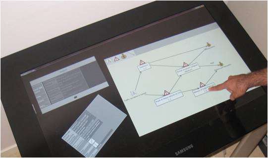
The executable prototype of the BRIDGE Risk Analyzer is developed as a Microsoft PixelSense application for the Samsung SUR40. Samsung SUR40 is a computer built as a table with the table top made up by a 40'' multi-touch screen.
The current prototype has functionality for
- Creating and editing risk diagrams, and
- Communicating with the Dynamic Expertise Integration Network (DEIN).
The latter is achieved by connecting to middleware provided by the BRIDGE project.
Important next steps include providing support for geographical location of risks and attaching more information, such as check lists and potential mitigation options, to risk models.